North Country explorer from
Mileage/Elevation Gain: Approximately 12 miles/4,200 feet
Route: South Meadows –Marcy Dam-Avalanche Lake-Trap Dike to the 2011 “Trap Dike Slide”-Summit-Lake Arnold-South Meadows.
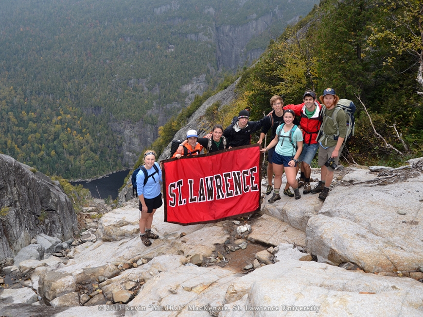
Climbers: Samuel Hecklau, Jace Mullen, William Hearty, Eric McIntyre, Caitlin Kelly, Margaret Chandler, Sophie Janeway, Alexander Ball, Kevin MacKenzie.
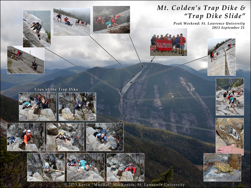
Photo 1: Trap Dike from Algonquin in 2012. The lower part of the dike is occluded.
Photo 2: The crew just before the slide.
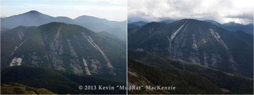
Photo 3: Referenced below…Before and after Tropical Storm Irene. The new slide in the right-hand photo is called the Trap Dike Slide. The dike was also scoured.
Additional Photos on Facebook at: https://www.facebook.com/media/set/?set=a.10151865713746308.1073741832…
-------------------------------
I fretted about the weather for a few days prior to this trip since the forecasts heralded rain sometime over the weekend. The timing, however, seemed to bounce around significantly (Thank you to my wife Deb who had an eye on the radar for me!). Rain and the Trap Dike just don't make a safe combination! Finally, it looked like a window of opportunity opened as I checked the internet during the evening of the 20th. The following morning, I scowled at the heavy clouds clinging to Colden, Algonquin and a host of other nearby peaks.
Beginning at about 7:30 a.m., the group set a good pace in the blustery yet warm weather. We covered the five miles to Avalanche Lake in about 1 hour 45 minutes taking a quick break at the northern edge. A SSW blew strongly down the length of the lake as we climbed on the boulders and hitch-up Matildas (boardwalks anchored in Avalanche Mountain) along the western shore. Erik readied a rack of cams and rope (a precautionary measure) when we arrived at the base of the dike while some of us refilled our water supply at the base of the dike. We were climbing by about 10:15 a.m.
The cloud ceiling held at around 3,000 feet in elevation when we began, lifting as we ascended. Also (and to my delight) there wasn’t a waterfall cascading down like so many other times I’ve visited the dike. This made both climbing and my job as photographer a bit easier. The first several hundred vertical feet of ascent is easy--scrambling up blocky steps of basalt. It leads to what is called the ‘Crux’, a seemingly vertical tier of steps, some of which can be loose and slippery.
This is usually the first test of nerves for those new to the dike. I climbed first and assumed my usual perch on a platform of stone at the top. No one hesitated and all went well. The rope and cams wouldn’t be needed, but I was still thankful they were handy. Shortly after, a few veins of quartz and a large toad captured our interest and gave me a chance to catch my breath.
A few hundred vertical feet higher, we passed a massive piece of anorthosite that moved off the mountain in 2011 when Tropical Storm Irene created the “Trap Dike Slide”, the highest slide that leads directly to the summit. In prior years, well over a century, the traditional exit was a couple hundred feet lower on a larger slide likely created in 1869.
The slide is mostly clean which makes for good friction climbing. What mud is still leftover lies primarily in small obvious clumps except just below the headwall…the top segment of slab. Different students chose different routes up the footwall of the slide as they exited the Trap Dike. By now, I’d taken over 200 photos and made great use of the SLU banner that Sam kept in his pack. We finally broke through the cloud ceiling at about 4,300 feet in elevation…they’d lifted over 1,000 feet since the beginning of the climb. The top of the slide was wet and visibility dropped to around 75 feet. Moments later after a short bushwhack, we were seated on the summit proper celebrating a successful and safe climb! The time was only 11:45 a.m.
The summit was under assault by strong winds, something we largely avoided in the protection of the dike and even on the slide. After eating a snack and taking some interesting summit photos, we began the trek down the muddy trail to the north summit. It was there that the sun finally decided to make a bold appearance…better late than never.
Fast forward about 45 minutes to lunch along the shore of Lake Arnold. The wind still had a presence, but was much tamer. A relaxed walk out found us back at the trailhead at a bit before 5:00 p.m.