The North Country is home to a rich set of state parks, but have you ever wondered how these beautiful, serene places came to be? Many of them sit on land that was once heavily used for logging, even before the timber industry dominated the landscape. These sites are the historical lands of the Mohawk and Iroquois, which are members of the Haudenosaunee. Over time, local advocates and state organizations stepped up to recoup these spaces into recreational parks which are now carefully managed for a future where everyone can enjoy the state parks for generations to come. Let’s take a closer look at several parks in St. Lawrence County by exploring their industrial pasts, how they became parks, and the unique ways each one is managed today to ensure their use for future generations.
Before industrialization of the waterways and surrounding areas, which are now home to state parks like the northern area of the Adirondacks, Eel Weir, Higley Flow, and Cole’s Creek, Native Americans were the stewards of the land. The nations of Mohawk and the Iroquois used rivers like the Raquette, Grasse, Oswegatchie, St. Regis, and St. Lawrence for transportation of people and products. These rivers were also used for fishing and hunting, as well as areas for spiritual ceremonies to be held. Guiding them was the Seven Generation Philosophy, which is the principle that states modern-day decision making should consider the well-being of the seventh generation from now. This principle was one of the reasons that traditional hunting, fishing, and settlement practices consciously have a low impact on their environment.
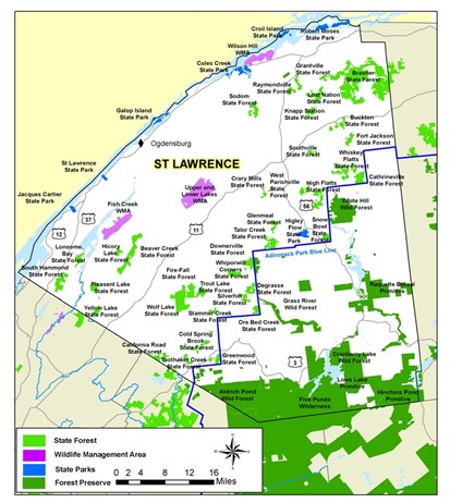
Fast forward to the 19th century, and St. Lawrence County is the largest county in New York State and the fifth largest east of the Mississippi River (the other four larger counties are all in northern Maine). Because of its size and natural diversity, it’s home to a wide range of parks including Higley Flow, Eel Weir, Coles Creek, and the northwest corner of Adirondack Park. But long before they became popular recreational areas, these places were critical to the development of the region’s logging and mining industries.
The northern parts of the Adirondack Park in St. Lawrence County—including towns like Colton and Parishville—are important protected lands. The Adirondack Park was created by the New York State Legislature in 1892 with the Adirondack Park Enabling Act to encompass forest preserve land. Forest preserves were created in 1885 as part of the New York State constitution over growing concerns for diminishing water and forest quality. They are governed largely by the “Forever Wild” clause in the New York State Constitution (adopted in 1894). Before its protection, there was little in the way of environmental protection. This led to issues with massive deforestation due to logging. With deforestation and unhealthy forests, wildfires ran rampant throughout the area. Large areas of land were sold to private landowners who monopolized the natural resources at the expense of the local community. Now the “Forever Wild” clause prohibits logging and development on forest preserve lands and has greatly increased healthy forests in the county.
Unlike the NYS Office of Parks, Recreation and Historic Preservation (which oversees places like Higley Flow and Coles Creek), the Department of Environmental Conservation (DEC) is responsible for managing Adirondack Forest Preserve lands. This means that conservation strategies differ. DEC lands are often more remote, with fewer developed facilities and a focus on wilderness preservation. However, both agencies uphold sustainability and Leave No Trace principles to ensure long-term protection of these natural areas.
In the west of St. Lawrence County near the Oswegatchie River, Eel Weir was once the site of Root’s Mill and the Eel Weir Mill. However, the historical records of these mills are limited, and it remains unclear if they were sawmills or grist mills. Additionally, the exact date of establishment for Eel Weir State Park is unclear (somewhere between the 1930s and 1940s). Eel Weir eventually transitioned into a state park through a mix of local advocacy and state recreation initiatives. The name Eel Weir comes from the traditional Native American fishing traps that were made of wood and stone and used to trap migrating eels.
Today, Eel Weir’s management focuses heavily on aquatic conservation. The park works with local anglers and paddlers to manage the spread of invasive water chestnuts along the river. This collaboration is key to maintaining the health of the Oswegatchie and ensuring good conditions for fishing, paddling, and wildlife. For example, if the invasive water chestnut is left unchecked, it can start to dominate the waterway. The water chestnut will create vast mats along the surface of the water and block sunlight from reaching the bottom, where other native aquatic plants are. Blocking sunlight from these plants means they can’t produce the energy they need to survive, killing them off and removing the native shelters and food sources that native animals rely on.
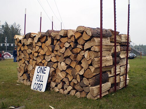
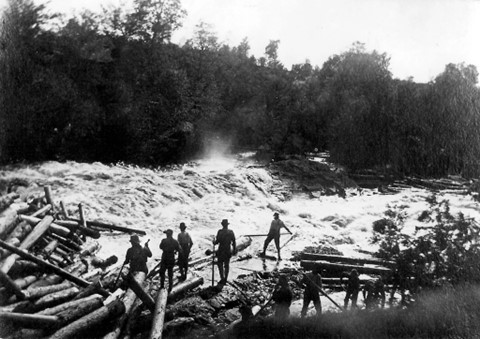
Located along the Raquette River, Higley Flow was once a hub for the timber industry. In the 19th and early 20th centuries, the town of Colton was home to three sawmills, two grist mills, two tanneries, and a pulp mill. The area that is now Higley Flow was one source for the lumber needed to power these mills. An example of the scale of wood needed is the S.R. Spaulding & Sons St. Lawrence Tannery. This single operation needed 5000 cords of hemlock bark and 500 cords of wood to heat the building annually. One cord of wood is equivalent to 4ft x 8ft x 4ft of wood stacked.
In the 1920s, the Niagara Mohawk Power Corporation built the Higley Dam, flooding the area and forming one of the reservoirs we know today. Five more dams would follow, creating a chain of reservoirs up the Raquette River. By 1963, the site was converted into a state park. Higley Flow is managed to balance recreation with ecological restoration. The park works to remove invasive species like honeysuckle, promote forest regrowth, and to encourage low-impact recreation. Trails and campsites are well-defined to minimize erosion and habitat disturbance.
Another North Country state park is Coles Creek, located in Waddington along the St. Lawrence River. The park was home to the Waddington Sawmill, another key part of the region’s logging economy. Like other parks, it was created during a wave of recreation expansion by the state in the 1960s. What sets Coles Creek apart is its focus on protecting shorelines and grassland habitats. Management here includes selective mowing to protect ground-nesting birds and native pollinator plants. They also maintain natural shoreline vegetation to serve as a buffer against erosion. These practices help preserve both the ecological integrity of the river and the visual beauty of the park.
With these parks being maintained for future generations, there are opportunities for everyone in the North Country to take advantage of. Whether this is going camping, fishing, hiking, biking, swimming, tanning on the grass, nature viewing, or anything else, be sure to capitalize on all these parks have to offer. Explore the human history that exists within the nature surrounding us. Maybe even consider joining a local organization to help take care of our great parks as well. Happy recreating!