It feels like every other week this past summer there is a heat advisory for air quality. With all the smoke rolling across our skies this past summer it leaves us wondering where is it burning? And why isn’t it burning here?
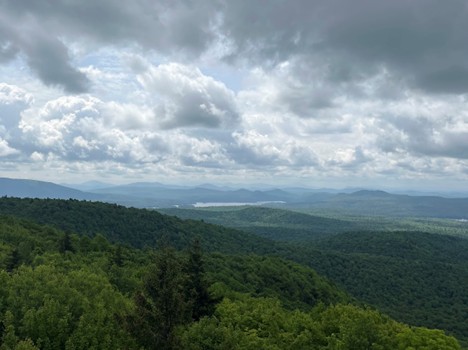
Now this is an interesting question because as many of you may know there are multiple fire towers to the south of St. Lawrence County bordering the edge of the Adirondack Park. To the south of the county Mt. Arab hosts one of those fire towers. Observation from the mountain was established in 1911 and the fire tower itself was built in 1918. This tower along with a couple dozen others in the Adirondack Park, were built in response to a devastating fire in 1903, also known as The Great Fire. Though the numbers are debated a bit, this fire destroyed between 460,000 and 600,000 acres of forest. This is about 1.9% of the NY State. With the last substantial forest fire burning in 1913, the fire towers now serve as historical landmarks, not as functional warning systems.
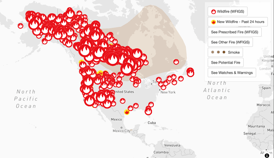
So if the Adirondacks aren't burning anymore, where is all the smoke coming from? From the north and the west. Like clockwork the western United Stated and central western Canada burn, every, single, year. The global wind patterns move that smoke via the westerlies (west to east winds) towards the North Country. So even though we don't have fires ourselves we are impacted by the particulate matter carried across the continent.
However, this still leaves a few questions unanswered. One being why does the American west burn periodically? The answer to this stems from forest ecology. Broadly, forests can be separated into two general groups: coniferous and deciduous forests. In coniferous forests you will find more trees that bear needles and pinecones. The American west receives more polarized weather due to its Mediterranean climate giving it hot summers and cold winters. These dry hot summers with months of no precipitation cultivate ideal conditions for fire. Deciduous forests on the other hand dominate the eastern ecology. With the expanses of maples, birch and beach trees that people flock to every fall to see their colors change. These forests are moist, receiving more consistent rain fall throughout the year. If you didn’t notice, it rained a lot earlier this summer and we saw historical flooding around this time last year. Due to the eastern humidity and lack of tinder-like conditions we don't burn on the same scale that the American west does.
To put The Great Fire into perspective, 13.6 million acers of Canada has burned this summer which is almost half the size of New York State or Croatia. 2.5 million acers burned in the province of Manitoba alone. This is aproximetly1.8% of Manitoba's land mass, so comparable to the 1.8% that The Great Fire burned in NY back in 1903. However, we need to remember that Canada and the rest of the American west have been experiencing devastating fires like this year, every year for some time now.
There is a stark difference between the forest compositions in the east and west that plays an important role in fire suppression and acceleration. The Great Fire of 1903 was proportionally devastating, so why have we not had one so big since. The answer lies in what the communities in the Adirondacks did after The Great Fire. It was determined that a lot of the burning was due to discarded slash, a byproduct of logging that is very flammable. Additionally, trains and train tracks were playing a role in igniting the fires. For example, sparks flew out of smokestacks and hot coals fell off the locomotives onto or off the tracks. Though it was law to have steel netting to prevent sparks escaping few companies adhered to this rule. In 1909 after the two devastating fire seasons a law was passed that required locomotives from April 13 through October 31 to only burn oil to prevent sparks. This crack down of regulations and enforcement, such as giving governors the right to close forests both public and private during seasons of high fire risk, served the Adirondacks well in suppressing fire risk in the early 1900’s.
There is a vast difference between fires in the east and the west. Additionally, there are global climate patterns that affect the movement of smoke. Notably, there is a history of fires in NY which lead to the construction of many fire towers, including a few in St. Lawrence County. To learn more about fire history in the Adirondack's the Adirondack Almanack is a fantastic resource. For a full list of fire towers, you can also visit the Adirondack Mountain Club’s ADK Fire Tower Challenge page. Remember when the next fire season in the west starts next spring to keep an eye out for air quality before engaging in your preferred outdoor activities. Have fun, be safe and remember to get up and get outside with Nature Up North.